Geocodes
DM
Latitude and longitude fields are populated and persisted for addresses after an address is cleansed in Network MDM.
Geocodes can be used in downstream systems to assist your business processes: for example, event planning and sales performance.
Example use cases
You can use the data to visualize the following on a map:
- HCP locations - Use the data to understand where HCPs practice within proximity to a organization when setting up events.
- Sales data on individual geocoded HCPs - Use the data to compare it against sales data tied to a territory to identify where sales are under performing.
- Coverage across regions - Use the data to align sales reps accordingly.
Supported countries
Geocodes are available for all countries. Address cleansing must be enabled in your Network MDM instance. These values will display on address records after they are loaded, or after they have been updated.
View geocodes
To view the geocodes on an address, click the Extended Info link at the bottom of an address.
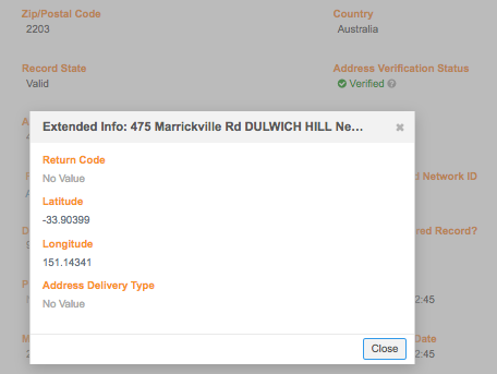
The Latitude and Longitude fields are included on standard profile layouts by default. If you use custom profile layouts, add these fields to the Address section on the layout so you can view the data on record profiles.
Geocode accuracy
A geocode accuracy field is used to understand the quality of the geocodes that are returned by Network MDM's third-party address cleansing service. For example, you can use the Geo Accuracy code to troubleshoot inaccurate cluster calculations.
Geocode data is available for all countries.
Enable the field
The geo_accuracy_code__v field is enabled by default in all Network MDM instances. The field cannot be disabled.
The field is populated (along with the latitude and longitude fields) when an address is cleansed. Address cleansing occurs when addresses are added or updated in your Network instance.
Display data
The Geo Accuracy Code field is added to standard profile layouts by default. The data displays in the Extended Info link on addresses. If you use custom profile layouts, add the field to the Address section on those layouts so you can view the data on record profiles.
Geo Accuracy codes
Geo Accuracy codes contain two values:
-
status - P (Point), I (Interpolated), A (Average), U (Unable to geocode)
- level - 4 (Premise), 3 (Thoroughfare), 2 (Locality), 1 (AdministrativeArea), 0 (None)
For more information about the values and their meaning, see the documentation from the address cleansing service: https://support.loqate.com/documentation/reportcodes/geoaccuracy-code/.
Examples
A Geo Accuracy code could be one of the following values:
- P4 - A single geocode matched the address using the premise.
- A2 - Multiple geocodes matched the address using the locality. An average was used to generate the result.